
Overview:
The Holt-Apache Trail, #181, takes you up the west-facing slopes of the Mogollon Mountains to a view point on the summit block of Holt Mountain. A history of wind and fire has resulted a thin patch of snags that opens to terrific views across the Dry Creeks region of the Mogollons. My turn-back time had arrived so this report does not describe the trail where it ascends the last few hundred feet to the summit of Holt Peak. On a longer day that should be easy to do. It might be even more rewarding to continue along the Apache-Holt trail for another half mile while searching for views down Whitewater Creek and into the heart of the Gila Wilderness. The trail is moderately steep, clinging to canyon bottoms in the first stretch and then mounting well-engineered switchbacks to bring you up out of the canyon. Unfortunately, the trail is being abandoned by the Forest Service. You are needed! Hike this trail and your very tracks will assist in keeping this gorgeous national resource open.
Edit: Josh (see comments) reports that the Gila Backcountry Horsemen have greatly improved the trail up to the Camp Creek saddle. All the more reason to go!
Driving Directions:
- From US-180 and NM-90 in Silver City, NM, go west onto US-180.
- After 53.7 miles on US-180 go right onto Sheridan Corral Rd (gravel). The road is officially signed CO54, but there is an informal sign attached to a fence saying “Sheridan Corral”.
- After 4.0 miles on Sheridan Corral Rd arrive at trailhead at end of road
Sheridan Corral Road is currently in good shape. All the maps I’ve seen depict a loop at the end of Sheridan Corral Road. That loop may exist, but it looks as if it might only be accessible to ATV drivers. If you are driving a truck or car then the end of the road is a smallish gravel pad in front of a weathered trailhead kiosk. I suspect that horse-folk use this trail. Please leave the gravel pad open so that those dragging a horse trailer can turn about. There is a gravel pull-out beside the road just before the pad. You can park in that pull-out.
Trailhead:

The trailhead is just a gravel pad and kiosk. There is no trash, vault toilet or water service. You should not count on water running in the canyon (bring your own). There are picnic tables and vault toilets in the Aldo Leopold Vista on US-180, near mile marker 63 (just a few miles south of Sheridan Corral Road). A sign near the start of the trail says that the trail is no longer maintained and that it may be hard to find in places. That last warning is not currently warranted. Finding the trail was straight forward, even when the tread was buried in a half foot of snow.
Data:
- starting elevation: 6354 feet
- ending elevation: 9377 feet
- net elevation gain: 3023 feet
- total gain: 3804 feet (gps)
- total decent 3832 feet (gps)
- distance: 5.0 miles (one way)
Hike Description:

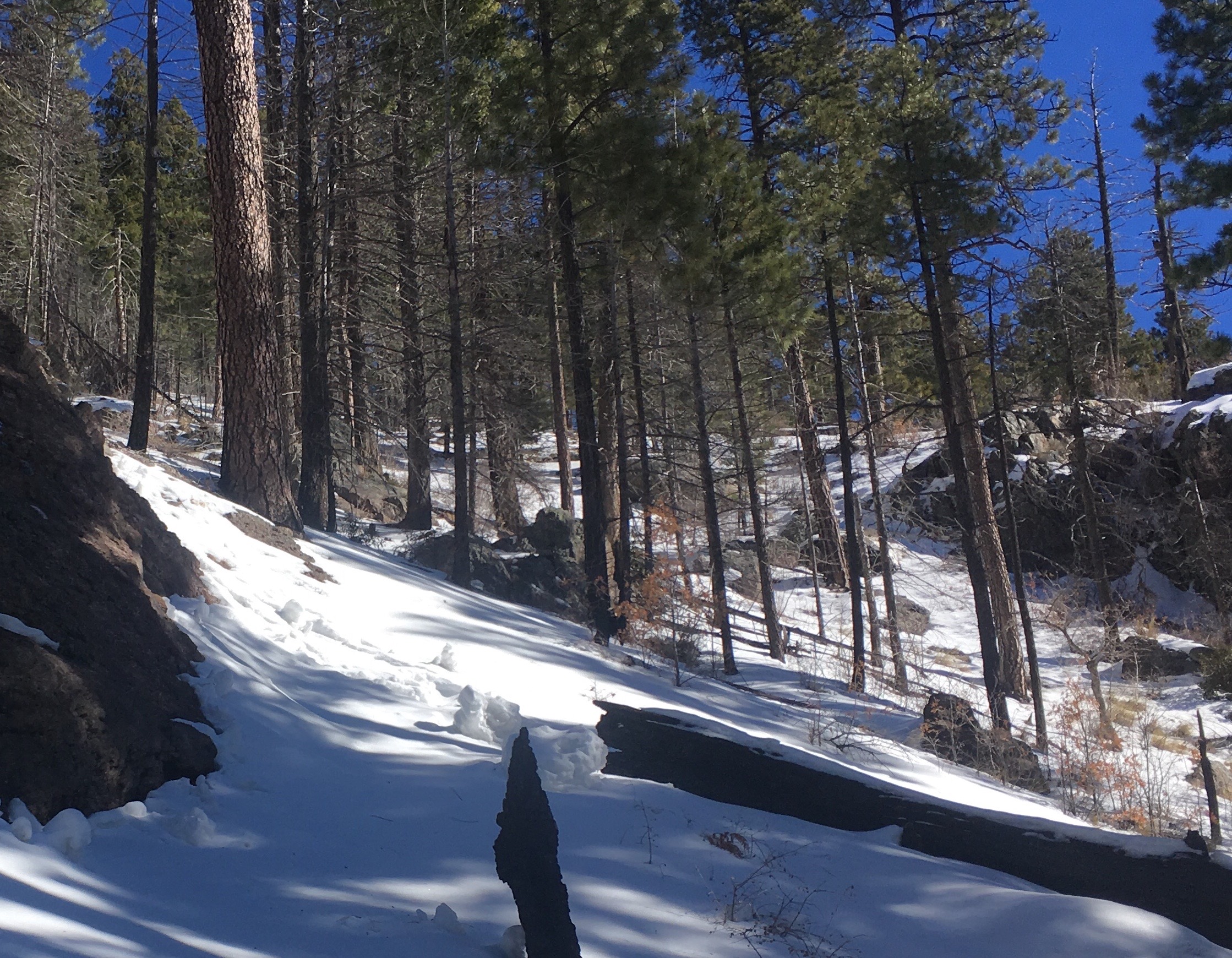
There is an apparent trail junction right behind the trailhead kiosk. Veering off to the east (to your right, looking uphill) lies a two-track. This may be part of the old loop that once graced the end of Sheridan Mountain Road. You will want to bear northeast (to your left looking uphill). That will take you past a bright yellow warning sign saying that the trail is abandoned and may be hard to find. The trail ascends for a short ways, gaining the top of the ridge between Sheridan Corral Creek and the unnamed canyon to the north. On the ridge the trail meanders back and forth until you enter the Gila Wilderness at 0.6 miles from the trailhead. The signage for the Wilderness boundary is falling to pieces. Past the signs the trail begins a short drop to the canyon bottom. The tread rounds a broad buttress and views open to Sheridan Peak on the east side of the canyon. Above you, on the west side, is much evidence of the Whitewater Baldy Complex fire of 2012. It must have burned hot. Even now, seven years on, the hillside is covered with patchy grass and a strikingly sparse scattering of gray oak.

The fire damage extends all the way to the canyon bottom. This region, protected from winds by canyon walls, is a continuous display of shriveled firs and blackened pines. On this day the creek in the bottom of the canyon was roaring away, displaying a gray-green coloration from the sand and clay it was hauling down from the heights. (There had been recent rain and snow storms). As you continue upstream you will encounter a monumental boulder in the canyon bottom, at 1.5 miles from the trailhead. This boulder may have once been a fin of rock that then wore into a hoodoo, then into a “hanging rock” and then losing to gravity to become a “settling rock”.

The trail twists back and forth across the creek while ascending at a gentle rate. As you pass the boulder you may notice that the fire devastation has eased. Huge old ponderosa and Doug Firs are present, sometimes blackened around their bases but still thriving. At 2.0 miles the trail enters a level, meadowy stretch and comes to a signed junction. The North Fork Big Dry Creek Trail #225 departs to the right. Veer slightly left to stay on the Apache-Holt Trail.

Both of the canyon rims lower as you ascend. The canyon walls open broadly to the sky. The creek bottom is warmer and brighter. The canyon is still quite dramatic, as the rim features tall hoodoos, fins and crown-shaped outcrops. Apparently this segment escaped the fire entirely. The understory includes a particularly clingy form of bramble that can slow your progress considerably. It was a good idea to have gaiters just to deal with the brambles. On this date footprints in the snow showed the passage of both deer and elk.
At 3.4 miles the trail leaves the bottom of the canyon and begins a series of carefully constructed switchbacks. The trail builders have thrown long rock walls to shore up the downside of the trail wherever needed. Scratch your head and ask how it is possible that such an investment could possibly be abandoned. The slope above the trail is steep in places. In wintertime you may see snow pinwheels (also known as “death cookies”) scattered along the hillside. These are thought to be evidence of unstable conditions. Exercise some thought before crossing any snow-choked chutes. Up and up and up! Although really it is only a half mile of switchbacks before the trail lurches to your right and makes a long, flat contour to the east. A mosaic of all-green patches and all-burned patches arise at this level, with the burned patches providing you with views back down the canyon.

The trail eventually reaches a rib-top and turns uphill to follow the rib towards the high ridgeline. Views of Holt Peak can be seen filtered through the evergreens. This is a gorgeous ramble through dense Douglas firs. The snow began to accumulate (on this date) and the junction of the Apache-Holt trail with Holt Gulch Trail #217 was obscured. Fortunately there was enough trail evidence (such as sawn logs or water bars) poking through the snow that the main trail could be followed to the ridge.

The trail slowly climbs to the main ridge line. When you reach the ridge it is worth turning north, off trail, and ascending towards Holt Peak for another hundred feet through open forest. You will find a stark, nearly snag-free burn with views swinging from the east down to the southwest. Looking across both the Big Dry Creek and Little Dry Creek drainages you will see Black Mountain and Sacaton Mountain, with Mogollon Baldy peeking over the ridge between them. You have almost innumerable options at this point. If you have enough daylight hours then the summit of Holt Peak is immediately above you. Energetic campers will want to continue along the Holt-Apache trail into the Mogollon’s high country. Time-limited day hikers, however, will probably want to soak in the sights and return the way they came.
Recommendations:

- As with other hikes in the Mogollon Mountains, dedicating just a single day to this hike is going to be frustrating. There is so much you won’t get to see! From my turn-back point it would be only 4.6 more miles to Spider Saddle. From the saddle a range of summits becomes accessible. These include Grouse Mountain, Indian Peak, Black Mountain, Center Baldy, Whitewater Baldy, Willow Mountain and many others. If you have the time then treat this hike as just the approach-leg for an extended stay.
- Haven’t got a free weekend? Then just do this hike! The canyon is beautiful and the views at the top are great. Plus, this trail (like many others in the Gila) badly needs greater boot-sole solace. Your efforts here will help to keep open a hiking gem.
- I went through one and a half liters of water on a warm (50 degree) winter’s day. That was plenty. If your own trip is planned for the truly warm months, however, then factor in the effects returning through burned areas (with little shade) in a southwest-facing canyon. The rush of water described in this report was strongly influenced by a recent snow storm and a subsequent rain storm. The canyon bed is likely to be dry in the pre-monsoon season.
- Consult the weather reports before going on this hike. The remaining snags are aging fast and wind will eventually topple them all. In recent years the snow pack has been terribly light and avalanche concerns have been almost negligible. That said, do watch for patterns of storms that might suddenly increase the risk. There are chutes here that raise your wintertime risk-levels.
- I heard just one sharp sound that may have been gun fire. The Gila Wilderness does open for hunting. A National Park Service report (undated) says that turkey season is late April and early May. Deer and elk season for bow hunters is the first three weeks of September, while deer and elk season for rifle hunters is October and November. Bear and cougar season is December and January. An orange wardrobe will continue to be useful for at least another couple weeks.
Links:
There is a detailed route description from 2016 (i.e. post fire) at HikeArizona.
Closures and other official information can be found at the Forest Service site.
“Stav Is Lost” has a trip report that describes a foggy-day approach in wintertime New Mexico. The photos will give you a good idea of what you are heading into, with emphasis on how the 2012 Whitewater Baldy Complex fire took a big toll on this part of the world.
The Casitas de Gila page has a 2015 trip report, but one that only extends for the first 1.5 miles of the hike. The geological discussion at the end is very interesting. They also recommend picking a calm day.

According to the Gila Backcountry Horsemen website, they have done some maintenance work on this trail this year (2020). I hiked in over Memorial Day Weekend and found the trail easy to follow until Camp Creek Saddle. After that point it became severely overgrown with locust and choked with downfall. I fought on to Black Mountain, and returned to Camp Creek Saddle via the Golden-Link trail. While I found bits and pieces of tread, it was primarily a bushwack and I ended up staying a day beyond my plan because travel was so slow. A shame because the back of Big Dry on the Golden Link has stunning rock formations.
Thank you Josh, I put a comment into the intro to let people know. Thank you for your update!